
The Annapurna Circuit Trek is one of the most celebrated long-distance treks in Nepal and usually takes around 12–16 days, depending on the starting point, transport option, and walking pace. It circles the entire Annapurna Massif, moving through subtropical valleys, pine forests, high desert plateaus, and finally a glaciated Himalayan pass, giving trekkers one of the widest ranges of landscape and culture found on any trek in the world.
The Annapurna Circuit Trek altitude reaches its highest point at Thorong La Pass, 5,416 meters (17,769 ft) above sea level. The altitude is the defining challenge of the trek; the air at the pass carries roughly half the oxygen found at sea level.
With the gradual increase in elevation, trekkers can feel the thinning of the oxygen level well before reaching the pass itself. So, the Annapurna Circuit elevation is gained slowly over many days rather than climbing directly to 5,416 meters. The trek starts in the lower, terraced hills near Besisahar or Jagat, then climbs steadily through Dharapani, Chame, Pisang, and Manang before pushing on toward Yak Kharka and Thorong Phedi, the last stop before the pass. From here, the trail continues up to Thorong La, the highest elevation on the entire circuit, before dropping sharply to Muktinath on the other side.
The trail is not technical, but as the Annapurna Circuit altitude increases past Manang, trekking becomes considerably more demanding due to low oxygen, cold temperatures, and exposed terrain. As you climb from Manang (3,540 m/11,614 ft) toward Yak Kharka and Thorong Phedi, the thinner air can begin to affect breathing, energy, and sleep, and some trekkers develop symptoms of altitude sickness. If trekkers experience symptoms such as headache, nausea, dizziness, unusual tiredness, loss of appetite, or trouble sleeping, they should avoid climbing higher and consult their trekking guide. The entire trek depends on ascent rate, rest days, hydration, walking pace, and, most importantly, individual response to altitude. Trekkers must keep a steady pace and pay close attention to how their body reacts as the elevation builds.
Also, the trail involves long trekking days with steady uphill stretches for over a week before the single demanding push over Thorong La. Therefore, you should have solid stamina and be comfortable walking for five to eight hours a day across varied terrain. Compared to the Annapurna Base Camp trek, the Circuit is longer, higher, and considerably more serious from an altitude standpoint.
This elevation guide will help you understand where the Annapurna Circuit trail climbs sharply, where altitude gain becomes noticeable, and where the risk of altitude sickness rises. It will also cover acclimatisation strategy and preparation, so you know what to expect before heading toward Thorong La.
What is the Exact Altitude of the Annapurna Circuit's Highest Point?
The highest point of the Annapurna Circuit Trek is Thorong La Pass, at 5,416 meters (17,769 feet). It sits between the Manang valley and the town of Muktinath, marking the boundary between the lush Annapurna side of the massif and the dry, Tibetan-influenced landscape of Mustang. At that altitude, the trek briefly moves into a genuinely high-alpine environment, well above where most vegetation can survive.
Thorong La is a trekking pass, not a summit, so it should not be confused with the elevations of the surrounding peaks. Annapurna II, III, and IV, along with Gangapurna and Tilicho Peak, all tower well above 7,000 meters around the route, but trekkers only pass beneath them; Thorong La at 5,416 m remains the highest point trekkers actually stand on.
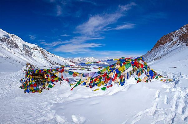
From Thorong Phedi (4,525 m/14,846 ft) or High Camp (4,925 m/16,158 ft), the elevation gain to the pass is roughly 500–900 meters depending on the overnight stop chosen. Although the distance covered is not huge, this gain feels significant because it happens above 4,500 meters, where oxygen is already scarce. The landscape around the pass is stark and alpine, marked by prayer flags, scree slopes, and views toward the Mustang ranges and Dhaulagiri.
As with most high-altitude figures, different sources list Thorong La at slightly different heights — some say 5,416 m, others 5,400 m. For trekking information, 5,416 meters is the standard, widely accepted altitude for Thorong La Pass.
Annapurna Circuit Trek Elevation Profile
The Annapurna Circuit route depends on the itinerary, but the standard version starts with a drive from Kathmandu toward Besisahar or Jagat, then follows the Marshyangdi valley up to Manang before crossing to the Kali Gandaki side of the massif. On a 14-day Annapurna Circuit itinerary, the trek passes through villages such as Dharapani, Chame, Pisang, Manang, Yak Kharka, Thorong Phedi, Muktinath, and Jomsom. Here is a table of their elevation profile:
| Location | Altitude (Meters) | Altitude (Feet) | Notes |
|---|---|---|---|
| Kathmandu | 1,400 | 4,600 | Arrival point before the trek to the Annapurna region. |
| Besisahar / Jagat | 760–1,300 | 2,493–4,265 | Low-altitude starting villages along the Marshyangdi valley. |
| Dharapani | 1,960 | 6,430 | Riverside village and gateway to the upper valley. |
| Chame | 2,630 | 8,628 | District headquarters of Manang, first real high-hill stop. |
| Pisang | 3,300 | 10,827 | Split point for the Lower and Upper (scenic) trail options. |
| Manang | 3,540 | 11,614 | Major acclimatisation hub with the most services on the trek. |
| Yak Kharka | 4,018 | 13,182 | High pasture settlement above the tree line. |
| Thorong Phedi / High Camp | 4,525–4,925 | 14,846–16,158 | Last stop before the pass; coldest and thinnest air on the standard route before Thorong La. |
| Thorong La Pass | 5,416 | 17,769 | Highest point on the Annapurna Circuit Trek. |
| Muktinath | 3,760–3,800 | 12,336–12,467 | Sacred pilgrimage site just below the pass on the Mustang side. |
| Jomsom | 2,720 | 8,924 | Windy Kali Gandaki valley town with flight and jeep access. |
| Pokhara | 822 | 2,697 | Main gateway back to the lowlands. |
Day by Day Elevation Gain on the Annapurna Circuit Trek
The elevation on the Annapurna Circuit increases gradually for well over a week before the sharp rise to Thorong La and the equally sharp drop to Muktinath. The table below shows the elevation change along a standard 14-day itinerary starting and ending in Kathmandu, highlighting the most significant gains and losses.
| Day | Trekking Route | Elevation | Net Elevation Change |
|---|---|---|---|
| Day 1 | Kathmandu Arrival | 1,400 m / 4,600 ft | — |
| Day 2 | Drive Kathmandu to Chamje/Syange | 1,410 m / 4,626 ft | +10 m |
| Day 3 | Trek to Dharapani | 1,960 m / 6,430 ft | +550 m |
| Day 4 | Trek to Chame | 2,630 m / 8,628 ft | +670 m |
| Day 5 | Trek to Pisang | 3,300 m / 10,827 ft | +670 m |
| Day 6 | Trek to Manang | 3,540 m / 11,614 ft | +240 m |
| Day 7 | Acclimatisation Day in Manang (side hike higher) | 3,540 m / 11,614 ft | 0 m (day hike to ~4,000 m) |
| Day 8 | Trek to Yak Kharka | 4,018 m / 13,182 ft | +478 m |
| Day 9 | Trek to Thorong Phedi / High Camp | 4,525–4,925 m / 14,846–16,158 ft | +507 to +907 m |
| Day 10 | Cross Thorong La Pass to Muktinath | Pass: 5,416 m / 17,769 ft Muktinath: 3,760 m / 12,336 ft | +891 m to pass; -1,656 m to Muktinath |
| Day 11 | Trek/drive Muktinath to Jomsom | 2,720 m / 8,924 ft | -1,040 m |
| Day 12 | Fly or drive Jomsom to Pokhara | 822 m / 2,697 ft | -1,898 m |
| Day 13 | Drive to Kathmandu | 1,400 m / 4,600 ft | +578 m |
| Day 14 | Departure | — | — |
Annapurna Circuit Altitude Compared to Everest Base Camp Trek
Both the Annapurna Circuit and Everest Base Camp are considered classic Himalayan treks, but they push trekkers to very different altitudes and in different ways. Everest Base Camp tops out lower than Thorong La, with trekkers reaching the base camp at 5,364 meters and continuing on to Kala Patthar at around 5,545 meters for sunrise views. Thorong La at 5,416 meters sits between those two figures, meaning the Annapurna Circuit's single highest point is roughly comparable to — and briefly higher than — Everest Base Camp itself, even though the Everest trek's overall high point (Kala Patthar) still edges it out.
The real difference lies in structure. Everest Base Camp includes two dedicated acclimatisation days, typically in Namche and Dingboche, and trekkers spend several nights above 4,500 meters. The Annapurna Circuit spreads its altitude gain over more days at lower elevation before a single, intense high-altitude push: one night at Thorong Phedi or High Camp, one demanding crossing day, and then a rapid descent to Muktinath. This makes the Circuit's altitude exposure shorter in duration but arguably more abrupt on pass day itself, with roughly 1,600 meters of descent packed into a single afternoon.
| Point | Annapurna Circuit Trek | Everest Base Camp Trek |
|---|---|---|
| Highest Point | 5,416 m (17,769 ft) at Thorong La | 5,545 m (18,192 ft) at Kala Patthar |
| Base Camp / Pass Altitude | 5,416 m (17,769 ft) | 5,364 m (17,598 ft) |
| Typical Overnight Max | 4,525–4,925 m (Thorong Phedi/High Camp) | 5,164 m (Gorak Shep) |
| Trek Duration | 12–16 days | 12–14 days |
| Acclimatisation | One rest day in Manang; altitude gain otherwise gradual | Two acclimatisation days, in Namche and Dingboche |
| Oxygen Level (approx.) | Roughly 50% of sea level at the pass | Roughly 50% of sea level |
| Altitude Sickness Risk | High, concentrated on pass-crossing day | High, spread across several high nights |
Both treks demand real respect for altitude, but they test the body differently: Everest Base Camp asks trekkers to sleep at extreme elevation for several nights, while the Annapurna Circuit asks for one very long, very high single push over Thorong La. The decision often comes down to time available, appetite for varied scenery, and whether you would rather face a longer high-altitude exposure or one intense crossing day.
(Note: See our popular Everest Base Camp Trek packages in Everest Region Trekking)
How Does Annapurna Circuit Altitude Compare to Other Famous Treks?
The altitude of the Annapurna Circuit is on the high end of Nepal's popular trekking routes. Compared to other well-known Himalayan treks, Thorong La sits close to the extreme end of what a trekking (non-mountaineering) route typically reaches. The table below shows a side-by-side comparison of the Circuit's highest point with other notable treks, such as Poon Hill, Annapurna Base Camp, Mardi Himal, Gosaikunda, Manaslu, and others.
| Trek | Highest Point | Difference from Annapurna Circuit | Altitude Category |
|---|---|---|---|
| Annapurna Circuit (Thorong La) | 5,416 m | — | Extreme |
| Poon Hill | 3,210 m | -2,206 m | Beginner |
| Annapurna Base Camp | 4,130 m | -1,286 m | Moderate |
| Mardi Himal | 4,500 m | -916 m | High |
| Gosaikunda Lake | 4,380 m | -1,036 m | High |
| Langtang (Kyanjin Ri / Tserko Ri) | 4,773–4,984 m | -432 to -643 m | Very High |
| Upper Mustang | 3,840–4,200 m | -1,216 to -1,576 m | Moderate |
| Manaslu Circuit (Larkya La) | 5,160 m | -256 m | Extreme |
| Kanchenjunga Base Camp | Approx. 5,140 m | -276 m | Extreme |
| Everest Base Camp | 5,364 m | -52 m | Extreme |
| Gokyo Ri | 5,357 m | -59 m | Extreme |
| Tilicho Lake | 4,919 m | -497 m | Very High |
Treks like Poon Hill, Annapurna Base Camp, Mardi Himal, and Gosaikunda all sit well below the Annapurna Circuit's highest point, making them more accessible for trekkers with limited time or high-altitude experience. Routes closer to the Circuit's league — Manaslu, Kanchenjunga, and Everest Base Camp — share the same "extreme altitude" category and demand similar levels of preparation, fitness, and respect for acclimatisation.
So at 5,416 meters, the Annapurna Circuit sits firmly among the most demanding standard trekking routes in Nepal. In exchange, trekkers get an unusually complete Himalayan experience: subtropical forest, high desert, glaciated pass, and Tibetan-influenced culture, all within a single continuous route.
Does Altitude Sickness Affect the Annapurna Circuit Trek?
Yes, altitude sickness is a real and significant concern on the Annapurna Circuit Trek. The trek spends multiple nights well above 3,500 meters and one full day above 5,000 meters, so there is a meaningful chance that trekkers may be affected by Acute Mountain Sickness (AMS). However, not everyone is affected, and the condition varies considerably from person to person.
The risk of altitude sickness rises steadily from Manang onward, and peaks around Yak Kharka, Thorong Phedi, and the Thorong La crossing itself. Trekkers may experience symptoms such as headache, nausea, vomiting, dizziness, fatigue, shortness of breath, and difficulty sleeping. If ignored, these symptoms can progress to more serious, life-threatening complications, including High-Altitude Pulmonary Edema (HAPE) and High-Altitude Cerebral Edema (HACE).
Physical fitness alone does not protect trekkers from altitude sickness. Strong, fit trekkers sometimes ascend too quickly simply because they can walk fast, which increases their risk rather than reducing it. Ascent rate, time spent acclimatising, prior high-altitude experience, and individual body response are the real determining factors.
If symptoms do not improve with rest, trekkers must descend immediately rather than push on toward the pass. Because a helicopter evacuation may be required in a genuine emergency, comprehensive travel insurance that covers high-altitude rescue is essential for anyone attempting the Annapurna Circuit.
Annapurna Circuit Acclimatisation
A well-planned Annapurna Circuit itinerary includes at least one dedicated acclimatisation day, almost always in Manang (3,540 m), before pushing on toward Yak Kharka and Thorong Phedi. Unlike the Annapurna Base Camp trek, the Circuit's extended high-altitude exposure makes a rest day here genuinely necessary rather than optional. On the acclimatisation day, trekkers typically hike up to a higher viewpoint — often above 4,000 meters — before returning to sleep at Manang's lower elevation, following the standard "climb high, sleep low" principle.
The most demanding elevation gain on the whole trek is the stretch from Thorong Phedi or High Camp to Thorong La Pass. At this elevation, trekkers should move at a slow, steady pace, avoid rushing on the steep switchbacks, and be prepared for an early pre-dawn start to cross before afternoon winds pick up.
If you want additional acclimatisation built into your schedule, Himalaya Heart can customise the itinerary to add extra rest days, particularly useful for first-time high-altitude trekkers. Experienced trekkers can sometimes manage with the standard single rest day, but everyone should monitor their body closely. If symptoms appear, stop ascending and rest; if they persist, descend without delay and follow your guide's instructions.
How Difficult is the Annapurna Circuit Trek Because of Altitude?
The Annapurna Circuit is graded moderate to difficult, largely because of the altitude gain from around 760–1,400 meters at the start to 5,416 meters at Thorong La. The lower and middle sections of the trek, through Dharapani, Chame, Pisang, and Manang, are demanding in terms of distance and daily walking hours but relatively manageable in terms of oxygen levels. The trek becomes considerably harder once the route pushes past Manang, where colder temperatures, thinner air, and more exposed terrain all combine.
- Thorong La sits at 5,416 meters, high enough that oxygen levels are roughly half of what they are at sea level. At that altitude, even a gentle incline can feel exhausting.
- The trek gains elevation gradually for the first week, then compresses a large share of the total ascent into the final approach to the pass, a pattern that makes the last few days noticeably harder than the first.
- The risk of altitude sickness increases sharply above 4,000 meters. Fitness does not prevent AMS, so paying attention to symptoms matters more than pushing pace.
- The stretch from Thorong Phedi to Thorong La is the most physically demanding section of the entire circuit: steep, cold, high-altitude terrain, often crossed before sunrise.
- Temperatures drop well below freezing near High Camp and on the pass itself, especially overnight and in the early morning, so proper cold-weather gear is essential.
- Rushing the ascent from Manang onward makes the trek considerably harder. Trekkers should walk steadily, take regular breaks, and stay well hydrated.
- Proper acclimatisation, including the Manang rest day, is essential to reduce the risk of altitude sickness before the Thorong La crossing.
Overall, the Annapurna Circuit is not technical, but it is significantly more physically and mentally demanding than shorter treks in the region due to its high altitude, long trekking days, and the single intense crossing of Thorong La. Fit, well-prepared trekkers can complete it comfortably with the right guidance, but altitude remains the deciding factor for everyone, regardless of fitness level.
How to Prepare for Annapurna Circuit Altitude?
Trekkers do not need mountaineering skills for the Annapurna Circuit, but arriving in good physical condition makes a real difference to how comfortably the trek — and especially the Thorong La crossing — unfolds. Preparation is mostly about cardiovascular fitness, a steady pace, hydration, sufficient rest, and genuine acclimatisation. Choosing an itinerary with sensible overnight stops is just as important as physical training.
- Build cardiovascular fitness: Start training several weeks in advance with activities such as hiking, walking, cycling, and swimming. Regular cardio combined with leg and core strength work will help with the long uphill stretches, stone staircases, and the demanding final push to the pass.
- Ascend at a steady pace: Avoid rushing, particularly from Manang onward. A slow, consistent pace lets your body keep up with the thinning air and gives it more time to adjust as elevation increases.
- Stay hydrated: Drink water consistently throughout the day rather than only when thirsty. Aim for roughly 4–6 liters daily, and carry a refillable bottle, topping up where safe drinking water is available.
- Get enough rest: Sleep and rest breaks matter more at altitude, since the body needs extra time to recover after several hours of walking each day. Rest becomes especially important around Manang, Yak Kharka, and Thorong Phedi.
- Understand altitude sickness: Learn the symptoms of AMS before you start. If any appear, stop ascending, rest, and consult your guide rather than pushing on toward the pass.
- Choose the correct itinerary: Pick an itinerary that includes at least one acclimatisation day in Manang and sensible overnight stops that increase sleeping elevation gradually rather than in large jumps.
Annapurna Circuit Altitude Map
| Day | Route | Elevation |
|---|---|---|
| Day 1 | Kathmandu Arrival | 1,400 m |
| Day 2 | Drive Kathmandu to Chamje/Syange | 1,410 m |
| Day 3 | Trek to Dharapani | 1,960 m |
| Day 4 | Trek to Chame | 2,630 m |
| Day 5 | Trek to Pisang | 3,300 m |
| Day 6 | Trek to Manang | 3,540 m |
| Day 7 | Acclimatisation Day in Manang | 3,540 m |
| Day 8 | Trek to Yak Kharka | 4,018 m |
| Day 9 | Trek to Thorong Phedi / High Camp | 4,525–4,925 m |
| Day 10 | Cross Thorong La to Muktinath | Pass: 5,416 m / Muktinath: 3,760 m |
| Day 11 | Trek/drive Muktinath to Jomsom | 2,720 m |
| Day 12 | Fly/drive Jomsom to Pokhara | 822 m |
| Day 13 | Drive to Kathmandu | 1,400 m |
| Day 14 | Departure | — |
Annapurna Circuit Trek Altitude & Elevation Guide FAQs
1. What is the highest point of the Annapurna Circuit Trek?
The highest point is Thorong La Pass, at 5,416 meters (17,769 feet). This is the crux of the trek and the point where altitude sickness risk peaks. Most itineraries cross the pass early in the morning, starting from High Camp (4,925 m) or Thorong Phedi (4,540 m), because winds pick up and weather worsens by early afternoon.
2. What is the elevation gain on the Annapurna Circuit Trek?
Trekkers typically start around 760–840 meters in the lowlands near Besisahar or Ngadi, climb to the 5,416-meter high point at Thorong La, then descend to roughly 800–900 meters near Tatopani or Nayapul. Total elevation gain over the full circuit is often 9,000–10,000 meters when every up-and-down section is added together, not just the net climb to the pass.
3. What is the elevation of Manang, the main acclimatization stop?
Manang sits at 3,519 meters (11,545 feet). Most itineraries schedule a mandatory acclimatization day here, since it's the last major village before the thinner air of the high camps. A short hike to nearby viewpoints like Gangapurna Lake or the Ice Lake trail (around 4,600 m) on the rest day helps the body adjust.
4. At what altitude does altitude sickness risk begin on this trek?
Altitude sickness (AMS) risk generally starts becoming significant above 2,500–3,000 meters, which on this route means from around Chame or Pisang onward. Risk rises sharply above 3,500 meters, which is why acclimatization days are built in at Manang and sometimes Chame or Pisang.
5. What is a safe daily elevation gain to avoid altitude sickness?
The standard guideline is to gain no more than 300–500 meters of sleeping elevation per day once above 3,000 meters, and to take a rest/acclimatization day for every 1,000 meters of net gain. The old trekking mantra "climb high, sleep low" applies well on this route, since day hikes to higher points followed by a return to a lower sleeping altitude aid acclimatization.
6. How many days does it take to reach Thorong La Pass from the start?
Most standard itineraries take 10–12 days to reach Thorong La from Besisahar or Syange, allowing for gradual elevation gain and at least two built-in acclimatization days (commonly at Manang and sometimes Chame). Faster itineraries exist but increase altitude sickness risk considerably.
7. What is the elevation of Muktinath, on the other side of the pass?
Muktinath sits at 3,760 meters (12,336 feet). It's reached the same day as the Thorong La crossing, via a steep descent of about 1,600 meters from the pass. This is one of the most physically demanding single days of the trek because of the combined high altitude and knee-punishing descent.
8. Which villages are the key altitude checkpoints along the route?
The commonly cited elevation checkpoints, west to east, are:
- Besisahar – ~760 m (trek start)
- Chame – ~2,710 m
- Pisang – ~3,300 m
- Manang – ~3,519 m (acclimatization stop)
- Yak Kharka – ~4,018 m
- Thorong Phedi/High Camp – ~4,540–4,925 m
- Thorong La Pass – 5,416 m (highest point)
- Muktinath – ~3,760 m
- Jomsom – ~2,720 m
9. Does altitude affect temperature on the Annapurna Circuit?
Yes, significantly. Temperature drops roughly 6–7°C for every 1,000 meters of elevation gained. At Thorong La Pass, pre-dawn temperatures can fall well below freezing (often -15°C to -20°C in peak winter months), even when lower villages like Besisahar are mild. This is why layered clothing and a warm sleeping bag rated for sub-zero temperatures are essential regardless of season.
10. Can I skip acclimatization days if I'm already fit?
No — physical fitness does not prevent altitude sickness, because AMS is caused by insufficient time for the body to adjust to lower oxygen levels, not by cardiovascular fitness. Even very fit trekkers can develop AMS if they ascend too quickly. Acclimatization days at Manang (or Chame) should be treated as non-negotiable on the standard itinerary, particularly for anyone who hasn't spent time at altitude recently.
Conclusion
The Annapurna Circuit's altitude of 5,416 meters at Thorong La is genuinely challenging, but it remains achievable for trekkers with solid fitness, a steady pace, and a properly acclimatised itinerary. The key is to respect the elevation gain from Manang onward and never rush the final approach to the pass. The Circuit is higher and longer than the Annapurna Base Camp trek, but it rewards trekkers with one of the most varied and complete Himalayan journeys available, from subtropical valleys to high desert and a genuine high-altitude pass crossing. Plan your Annapurna Circuit adventure with a proper itinerary and experienced guidance to manage the altitude safely while taking in the changing scenery and culture along the way. Join Himalaya Heart for your next Annapurna Circuit adventure.