
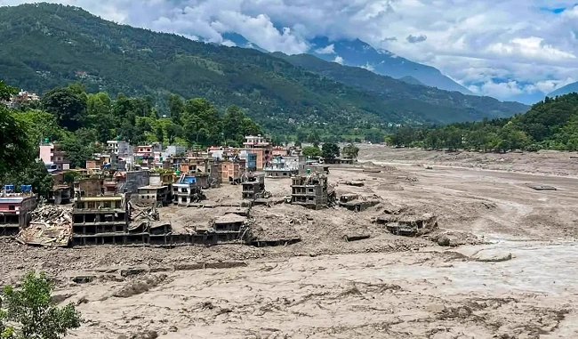
This page answers practical questions trekkers are asking, but it shouldn't read like an ordinary travel update. As of the most recent situation report, Nepal has confirmed more than 780 deaths and over 2,500 people still unaccounted for, with more than 9,000 rescued so far. Tibet has reported additional deaths and hundreds more missing on its side of the border. An estimated 90,000+ people have been affected across Rasuwa, Nuwakot, Dhading, Gorkha, Tanahun, Nawalparasi, and Chitwan. Search-and-rescue is still underway. With that context in mind, here's what trekkers need to know.
Q1: What exactly happened, and when?
At around 9:00–9:15 a.m. on Wednesday, August 26, 2026, a massive volume of water suddenly entered the Bhote Koshi River from the Tibetan side of the border and struck Rasuwa district with almost no local warning. There had been no significant rainfall in the area in the preceding 24 hours, which pointed investigators away from a normal monsoon flood.
Q2: What actually caused it?
The leading theory involves an ice-rock avalanche near Langtang Lirung that blocked a tributary stream (the Lhende Khola) roughly 20 km upstream in Tibet, creating a temporary debris-dammed lake. When that lake failed, it's believed to have released a glacial lake outburst flood (GLOF) — a wall of water, mud, and debris strong enough to register as a magnitude 5.2 tremor on seismometers, with a surge reportedly reaching around 100 meters above the river's normal level near the impact point. This isn't an isolated pattern either — the Bhote Koshi–Trishuli corridor saw a similarly deadly flood event in July 2025, and disaster experts point to accelerating glacial melt and glacial lake formation across the high Himalaya as a growing risk factor for this border region.
Q3: Which places were hit hardest?
- Timure – near the Rasuwagadhi customs crossing; the customs office and nearby structures were badly damaged.
- Syabrubesi – the main gateway town for Langtang trekkers; suffered major structural damage, with reports that a large part of the town was washed away.
- Betrawati and Trishuli Bazaar – hit as the flood moved downstream into the Trishuli system.
- Devighat (Nuwakot) – also affected downstream.
- Rasuwagadhi Rural Municipality – homes reported swept away, though many residents reached higher ground in time.
Local reporting indicates roughly 60 houses and two bridges were destroyed across the affected areas, and public transport between Kathmandu and seven districts along the route was suspended as a precaution. Fourteen hydropower projects and their transmission infrastructure were also damaged.
Q4: Is the road to Syabrubesi open?
No, not for normal travel. The Pasang Lhamu Highway — the route from Trishuli Bazaar through Betrawati and Dhunche to Syabrubesi — remains heavily disrupted and considered unsafe for travel. There is some encouraging movement: the Kathmandu–Dhunche section has reopened for light, four-wheeled vehicles. But the stretch on to Syabrubesi itself is not currently viable, and authorities have advised against travel on the wider Nuwakot–Rasuwa–Syabrubesi corridor.
Q5: Is the actual Langtang trekking trail damaged?
This is the most encouraging piece of news for trekkers: according to on-the-ground reporting, while Syabrubesi itself has been largely washed away, the trekking trail from Bamboo through Lama Hotel to Langtang Village and on to Kyanjin Gompa remains intact. In other words, the problem is concentrated at the road-accessible gateway, not the high trail most trekkers actually walk. That said, official confirmation is still limited, and conditions should be verified locally before you rely on this.
Q6: If Syabrubesi is inaccessible, is there any way to still do Langtang?
Yes, potentially — with a modified itinerary rather than the classic route. Local operators are discussing two workarounds:
- Start from Dhunche once the road resumes there, cutting out the Syabrubesi-to-Dhunche road stretch and rejoining the trekking trail from a point closer to the valley.
- Start from Kutumsang, approaching Langtang by combining it with the Gosaikunda trek — a longer route that avoids the flood-hit corridor entirely but adds extra days to the itinerary.
Neither of these should be attempted independently right now; they depend on road and trail conditions that are still being assessed, and should only be arranged through a trekking company actively coordinating with local authorities.
Q7: When will the classic Langtang route reopen?
There's no confirmed reopening date yet. Local authorities are currently prioritizing rescue and damage assessment in Rasuwa, and a reopening will only be announced once road and trail conditions have been inspected and stabilized. Trekking operators note this is likely to take weeks rather than days, but caution against relying on projected timelines — official, on-the-ground updates from local authorities are the only reliable source right now.
Q8: What if I already have a Langtang trip booked?
Trekking companies are actively managing this. Groups already on the trail or en route are being contacted directly and, where necessary, rerouted or held at safe waypoints. Guides are also working to confirm the safety of local staff and lodge owners based in the region. If you have an upcoming booking, most operators are offering flexible rescheduling, alternative itineraries in unaffected regions, or postponement at no extra cost — but you need to contact them directly rather than assume your original plan still stands.
Q9: Does this affect the Kailash Mansarovar Yatra too?
Yes. The Rasuwagadhi–Kerung (Gyirong) border crossing, the main overland gateway used for the Kailash Mansarovar Yatra from Nepal, runs directly through the flood-hit Timure–Syabrubesi corridor. With border infrastructure damaged and roads compromised along this stretch, the crossing is currently considered unsafe and unreliable for pilgrim transit as well.
Q10: Is the rest of Nepal safe to trek right now?
Yes. This is a Rasuwa/Bhote Koshi–Trishuli corridor event. Everest, Annapurna, and Manaslu — Nepal's other major trekking regions — sit on entirely different river systems and access roads and are running normally. A brief Prithvi Highway closure was reported but expected to clear quickly, and it's a minor factor for travelers heading toward Pokhara-based routes.
Alternative Trekking Destinations While Langtang Recovers
If your Langtang plans are on hold, here's a full look at what else is open and running normally.
Everest Base Camp (EBC) Trek
A 12–14 day classic through the Khumbu region — Namche Bazaar, Tengboche, Dingboche — to the foot of Everest, reached by flying into Lukla. Sits on the Dudh Koshi drainage, geographically separate from the Rasuwa flood zone. Unaffected; standard Lukla weather/flight caveats still apply.
Annapurna Base Camp (ABC) Trek
A 7–10 day trek from Pokhara through rhododendron forest to the amphitheater of peaks around Annapurna Base Camp. Unaffected by the flood; a good shorter alternative with dramatic mountain scenery.
Annapurna Circuit Trek
A 12–18 day route circling the Annapurna massif via the Marsyangdi valley, crossing Thorong La pass (5,416 m) into the Kali Gandaki valley. Access from Besisahar/Pokhara is unaffected.
Manaslu Circuit Trek
A restricted, less-crowded 14–18 day circuit around the world's eighth-highest mountain, following the Budi Gandaki — a river system entirely separate from the Bhote Koshi/Trishuli corridor. Requires a special permit and guide. Running normally, and a strong pick if remoteness was Langtang's draw for you.
Upper Mustang Trek
A 10–14 day high-desert trek into the former Kingdom of Lo along the Kali Gandaki valley, with cave monasteries, red cliffs, and Tibetan Buddhist culture. Requires a restricted-area permit. Unaffected.
Tsum Valley Trek
A remote valley trek often combined with the Manaslu Circuit (15–20 days total), known for well-preserved Tibetan Buddhist monasteries. Uses the same unaffected Budi Gandaki access as Manaslu.
Nar Phu Valley Trek
A hidden-valley trek (10–14 days), usually paired with the Annapurna Circuit, branching into two restricted, rarely visited villages. Same unaffected access corridor as the Annapurna Circuit.
Ghorepani Poon Hill Trek
A beginner-friendly 4–5 day trek through the Annapurna foothills to the famous Poon Hill sunrise viewpoint over the Annapurna and Dhaulagiri ranges. A good fit for a short original Langtang window. Unaffected.
Mardi Himal Trek
A quieter 5–6 day ridge trek with close-up views of Machhapuchhre (Fishtail), accessed from Pokhara. Unaffected and a good lower-traffic option.
Quick-Reference Checklist for Trekkers
- Do not attempt to reach Syabrubesi independently right now.
- Confirm any Langtang booking directly with your operator — don't rely on old itineraries or social media reports.
- Ask your operator specifically about the Dhunche or Kutumsang/Gosaikunda alternative routes if you still want to reach Langtang this season.
- If your dates are fixed, pivot to Everest, Annapurna, or Manaslu — all unaffected.
- Check Prithvi Highway and domestic flight status close to your departure date.
- Avoid riverbank areas anywhere in the flood-affected districts, even outside Rasuwa itself.
- Consider donating to the Nepal Red Cross Society or Nepal's official relief fund given the scale of need.
Bottom Line
The latest information suggests a more nuanced picture than "Langtang is closed": Syabrubesi and the road into Rasuwa are seriously damaged and inaccessible, but the trekking trail from Bamboo to Kyanjin Gompa is reportedly intact, and workaround routes via Dhunche or Kutumsang/Gosaikunda are being discussed by local operators for later in the season. For now, though, official guidance is to stay away from the affected river corridor entirely until authorities confirm it's safe. Everest, Annapurna, and Manaslu remain fully open, and any of the alternative treks above — from a short Poon Hill trip to the remote Tsum and Nar Phu valleys — make for a strong substitute while Rasuwa recovers.