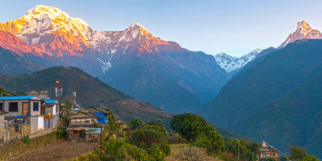

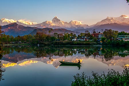
Sarangkot is the hill above Pokhara that most people picture when they imagine a Himalayan sunrise, snow peaks catching the first light, a lake town waking up in the valley below. It's a ward of Pokhara Metropolitan City now rather than a separate village, sitting on a ridge northwest of Lakeside, and it's the single most visited viewpoint in the Pokhara Valley.
This guide covers what people actually ask before visiting: how high it is, how to get there, when to go, what it costs, and what else there is to do once you're up there.
Where Is Sarangkot? Location and Distance from Pokhara
Sarangkot sits on a ridge in Kaski District, roughly 5 km from Lakeside by the direct hillside route and about 11 km by road, since the road winds around the hill rather than climbing it directly. It was an independent village until 2015, when it was formally merged into Pokhara as Ward 18.
From Lakeside, you have three practical ways to cover that distance:
- Cable car: about 8 to 10 minutes
- Taxi or private car: roughly 30 to 45 minutes by road
- Hiking: 1.5 to 3 hours depending on your pace and starting point
How High Is Sarangkot? Altitude and Elevation
Sarangkot's viewpoint sits at approximately 1,600 metres (5,249 feet) above sea level. You'll also see the more precise figure of 1,592 metres (5,223 feet) used in some sources, both are in circulation and refer to the same summit area, the small difference comes down to which exact point on the ridge is being measured. For comparison, Pokhara city itself sits at around 800 to 900 metres, so you're gaining roughly 700 to 800 metres of elevation on the way up, which is part of why the mountain views open up so dramatically once you reach the top.
This is a genuinely low-altitude viewpoint by Himalayan standards, well below the range where altitude sickness becomes a concern, which is exactly why it's accessible to almost anyone, no acclimatisation or trekking fitness required.
What Does the Name "Sarangkot" Mean?
"Kot" reliably means fort or fortified hilltop in Nepali, and Sarangkot was historically a hill-fort site, once linked to Kulmandan Shah, an ancestor of Nepal's Shah dynasty kings, before it became the tourism destination it is today. The "Sarang" part of the name has a couple of different local explanations in circulation, some tie it to "Sarun," a traditional shield-and-sword game once practised here, others connect it to "Sarang," referenced in Nepali folklore as a high-flying bird. Both readings fit the place: a fortified high point associated with either martial history or the idea of soaring above the valley.
Best Time and Best Time of Day to Visit Sarangkot
Autumn (September to November) offers the clearest, most reliable mountain visibility of the year. Spring (March to May) is the second-best window, slightly hazier some afternoons, but with green hillsides and rhododendron blooms lower down. Winter (December to February) can still deliver clear skies, mornings are just noticeably colder. Monsoon (June to August) is the one season to plan around if a clear sunrise matters to you, cloud and fog frequently block the view during these months.
Within any season, timing your visit to the day matters more than most people expect:
Sunrise: Arrive 30 to 45 minutes before actual sunrise, viewing spots fill up fast in peak season. Sunrise timing shifts through the year, roughly 6:00 to 6:30 AM in autumn and winter, closer to 5:00 to 5:30 AM in spring and summer, check the current local sunrise time the evening before.
Sunset: Less crowded than sunrise and, on a clear evening, just as striking, the light on Machhapuchhre and the Annapurna range at dusk is a genuine alternative if you'd rather not do the early start.
Things to Do in Sarangkot
Watch the Sunrise (or Sunset)
The core reason most people come. On a clear morning you'll see first light hit Annapurna I (8,091 m), Dhaulagiri (8,167 m), Machhapuchhre (Fishtail, 6,993 m), and, further along the horizon, Manaslu (8,163 m).
Ride the Annapurna Cable Car
Running from Sedibagar near Phewa Lake up to Sarangkot in roughly 8 to 10 minutes, this is now the most common way visitors reach the viewpoint, especially for a pre-dawn start. It typically opens around 5:00 AM to accommodate sunrise visitors. Ticket prices vary by nationality and change periodically, worth checking the current rate before you go rather than relying on an older quoted figure.
Try Paragliding
Pokhara remains one of the world's best-known tandem paragliding destinations, and Sarangkot's height and position over the valley are a big part of why. That said, the exact take-off point has shifted in recent years due to Pokhara International Airport's flight path rules, flights have moved between Sarangkot itself, Mandredhunga, and more recently Toripani, with landing sites also changing between Pame and Khapaudi. Book through a licensed operator and confirm the current take-off location and price when you enquire, this is one detail that's genuinely worth double-checking close to your travel dates rather than trusting an older blog post, including, to be fair, earlier versions of this one.
Hike Up (or Down)
If you'd rather walk than ride, routes from Lakeside or via Bindhyabasini Temple and Naudanda take roughly 1.5 to 3 hours depending on the trail and your pace, through terraced fields and small villages rather than dense forest. Many visitors ride the cable car up for sunrise and hike down afterward, or the reverse.
Photography
Sarangkot is a straightforward, reliable spot for wide mountain panoramas and sunrise/sunset timelapses. Drone use is possible in places but requires the correct permits, don't assume it's automatically allowed.
Explore the Village and Local Culture
Below the main viewpoint, Sarangkot is still a working village, home to Gurung and Brahmin communities. If you have time beyond the sunrise dash, a short walk through the village and a plate of dal bhat or gundruk ko jhol at a local teahouse gives a very different, quieter side of the place than the viewpoint crowds.
Where to Stay
Sarangkot has a small but genuine range of accommodation, from basic guesthouses to boutique lodges with mountain-facing balconies. Staying overnight means you can catch sunset and sunrise without an early drive up from Lakeside, and a clear night here gets you a proper look at the stars, something you won't get from town.
Costs and Practical Details
- Cable car: check current pricing directly, as rates differ for foreign and domestic visitors and are updated periodically
- Taxi (round trip from Lakeside): roughly NPR 1,000 to 2,000
- Paragliding (tandem flight): confirm current pricing and take-off location with a licensed operator, this has changed more than once in recent years
Frequently Asked Questions
How high is Sarangkot? Approximately 1,600 metres (5,249 feet) above sea level, sometimes cited more precisely as 1,592 metres (5,223 feet).
How far is Sarangkot from Pokhara? About 11 km by road, or roughly 5 km via the direct hillside route. The cable car covers it in around 8 to 10 minutes; by taxi it's typically 30 to 45 minutes; on foot, plan for 1.5 to 3 hours.
What is Sarangkot known for? Its sunrise view over the Annapurna and Dhaulagiri ranges, Phewa Lake and the Pokhara Valley below, and as one of the best-known paragliding locations in the world.
Is Sarangkot worth visiting? For most travellers in Pokhara, yes, it's a low-effort, low-altitude viewpoint with one of the more reliable Himalayan panoramas you can reach without any trekking experience.
What is the best time to visit Sarangkot? Autumn (September to November) for the clearest skies, spring (March to May) as a strong second choice. Avoid relying on monsoon-season (June to August) visits for a clear view.
Can you paraglide from Sarangkot? Sarangkot's elevation and position are still central to Pokhara's paragliding scene, but the actual take-off point has moved in recent years due to airport flight-path restrictions and currently sits elsewhere along the ridge (Toripani, at last check). Confirm the current location and price with a licensed operator when booking.
How do you get to Sarangkot from Lakeside? By cable car (fastest, roughly 8 to 10 minutes), by taxi or private car (30 to 45 minutes), or on foot (1.5 to 3 hours).
What does the name Sarangkot mean? "Kot" means fort or fortified hilltop. The "Sarang" element is explained differently across local sources, tied either to a traditional sword-and-shield game or to a mythical bird from Nepali folklore.
Is Sarangkot suitable for a day trip, or should I stay overnight? Both work. A pre-dawn cable car or taxi trip from Lakeside is enough for the sunrise experience. Staying overnight lets you catch both sunset and sunrise without an early departure, plus a clear night sky.